Mapping OS Monuments in the Highlands: Searching for evidence of the early triangulation surveys in the Scottish Highlands
courtesy K. Lilley
In 2021 ARCH worked with Prof. Keith Lilley, Queens University Belfast, to research and map the evidence surviving of the initial Ordnance Survey triangulation in the Highlands in the first half of the 19th century. Establishing a comprehensive mapping network was a mammoth task. Prof. Lilley has been involved in researching activity in Northern Ireland, and was keen to see what evidence might survive for the Scottish Highlands.
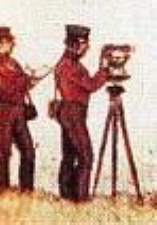
The lockdowns presented many challenges for community heritage projects, but as it turned out, also opportunites. Online sessions allowed participants from throughout the UK and abroad to work together on this project. The group first looked at documentary and map evidence of the initial triangulation stations in the Highlands. The first were established over 200 years ago, finishing in the 1840s/1850s. We all gained enormous respect for these surveyors, hauling heavy theodolites and other equipment up to some of the high, remote peaks in the Highlands, at a time when transport was difficult in many areas of the Highlands.
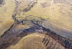
The initial triangulation stations required detailed measurements over some days, and as a result camps were established in many locations (known often as Colby camps, after the leader of the survey, Thomas Colby). While some camps are known in the Highlands, the group was able to identify other possible remains of these camps by using maps and aerial photographs. These now need to be groundtruthed, and ideally surveyed. In addition to the camps, triangulation pillars also survive, most from later re-triangulations.
The work of the OS in Scotland has been outlined in two papers by David Walker (Walker 2013; 2015, with details on available sources). The initial surveys took place between 1810 and 1822, led by Col. Colby, but in the Highlands only after 1819. The initial foray to the Highlands by Colby was described in a colourful memoir By J.E. Portlock, which included a letter by R.W. Dawson who accompanied Colby on one of his reccies into the Highlands.
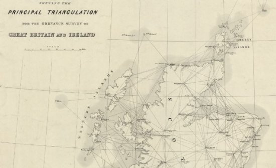
After 1822 the OS moved to Ireland, only resuming work in Scotland in 1838. At this point, some new sites were chosen, others dismissed, and some redone, in part due to new advances in the mathematics of triangulation. Colby undertook some observations, but soon returned to England leaving assistants to complete the survey (Walker 2015). An account by Alexander Ross Clarke published in 1858 provides a summary of work undertaken at this date. When compared to various maps (see Walker 2013; 2015), these sources allow a basic overview of the work of the initial triangulation in the Highlands, although there are some questions remaining. In particular, the ARCH project focussed on a map from 1856 in the NLS, together with Clarke’s account.
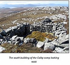
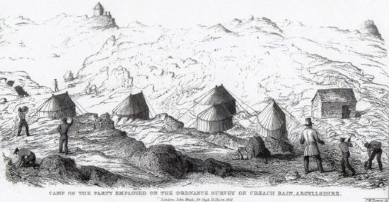
The detailed work for triangulation required several days’ work. In remote locations, these required camps to be set up. Fortunately an illustration survives of the camp at Creach Bheinn, Lochaber (MHG318; Canmore 23114), surveyed towards the end of the process in 1840. A stone built cookhouse near a number of tents were nestled below the summit, where a conical pillar is visible. Windbreaks were also constructed. The ruinous remains can still be seen at Creach Bheinn.
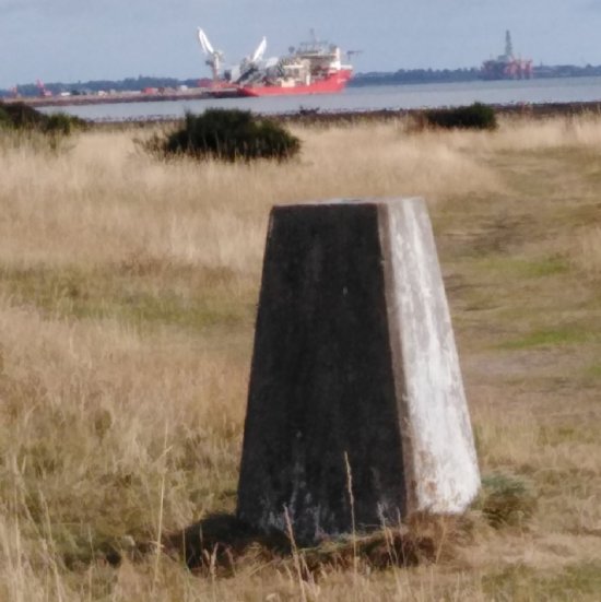
A pillar was erected at the point where the theodolite was set up. The early ones were stone built, and sometimes enclosed in a stone built shelter. Over the years, with re-triangulations, these pillars were taken apart, then rebuilt. Most now are a standard concrete design with an inset benchmark, product of 20th century retriangulation. However, because of the abandonment of some sites after 1838, there are a few candidates for possibly early remains.
Between c. 1850, the end of the initial triangulation, and the 1870s when the first edition OS mapping took place, there were clearly a number of new triangulation stations introduced. This work could use further similar analysis.
The ARCH project produced information about each site on the 1856 map or in Clarke 1858, and examined old maps and aerial photographs to try and identify sites. In addition, images submitted to www.trigpointing.uk and www.geograph.org.uk as well as other mountaineering websites were consulted. The resulting list is now ready for groundtruthing, and would make an ideal project with hillwalkers. The full document is in the ARCH website Document Library, in the OS Mapping Monuments folder, filename 'Principal Highland Trig Stations results of research 3-2021.
The project assembled a number of resources (see below), which have also been placed on the ARCH website in the OS Mapping Monument Project folder in the ARCH website Library. The ARCH YouTube channel also includes a talk by Keith Lilley, and recording from a workshop held in January 2021. These can be used to investigate the fascinating story of the initial OS triangulations in the Highlands, and provide inspiration to carry out similar work elsewhere.
Acknowledgements
A number of people generously donated their time on this project: Keith Lilley of Queens University Belfast, independent researcher David Walker, Chris Fleet of the NLS, Clive Boocock of the OS, and all the volunteers who spent hours pouring over aerial photos and maps.
Key resources:
Background
‘Mapping Monuments: a landscape archaeology of the Ordnance Survey’ Recording of talk given by Keith Lilley to ARCH 15-12-2020 is on the ARCH YouTube channel, or a PDF version of the powerpoint can be downloaded.
Lilley, Keith D 2017 ‘Mapping the Nation: Landscapes of survey and the material cultures of the early Ordnance Survey in Britain and Ireland, Landscapes 18:2., pp 178-199. Download PDF.
Lilley, Keith D 2018 ‘Surveying the surveyors’, Sheetlines 113, 6-12
Owen, Tim and Pilbeam, Elaine 1992 Ordnance Survey. Map Makers to Britain since 1791
'Account of the observations and calculations, of the principal triangulation; and of the figure, dimensions and mean specific gravity, of the earth as derived therefrom': Drawn up by Alex. Ross Clarke, 1858.
Read on line at https://babel.hathitrust.org/cgi/pt?id=uiug.30112065074673&view=1up&seq=7
Download Descriptions of Highland Trig stations (PDF)
Download Descriptions of equipment and triangulation logistics (PDF)
Download Tables of observations from Highland stations (PDF)
Download misc other pages relating to Highland stations (PDF)
Portlock, J E 1869 Memoir of the life of Major-General Colby: together with a sketch of the origin progress of the Ordnance Survey of Great Britain and Ireland
Read on line at https://babel.hathitrust.org/cgi/pt?id=mdp.39015031074423&view=1up&seq=13
or Download PDF of full text
or Download extract of pages relating to Highland sites (PDF)
Seymour, W A (ed) 1980 A History of the Ordnance Survey [warning: large file!] https://www.ordnancesurvey.co.uk/documents/resources/os-history.pdf
Sheetlines – publication of the Charles Close Society for the Study of Ordnance Survey Maps. Many are available on line, including:
- Walker, David L 2013 ‘The initial triangulation of Scotland from 1809 until 1822’, Sheetlines 98, pp 5-15.
- Walker, David L 2015 ‘The troubled history of the Scottish triangulation 1823-1858’, Sheetlines 104, pp 5-18.
- Thornber, Iain and Oliver, Richard 2011 ‘Colby’s camps’, Sheetlines 90, pp 18-22.
- Walker,David L 2014 ‘James Gardner – surveyor, computer, publisher’, Sheetlines 101, pp 31-38.
Trig points
https://trigbagging.co.uk/ provides locations by interactive map. For photos and advice on how to find them, see http://trigpointing.uk/
Types of Trigpoints – glossary from trigpointing.uk with pictures
Trig Point Walks on the Isle of Skye and Raasay, by Alistair Christie and Ian Stewart (2014, Strupag Publishing) – book with detailed routes to all 56 trig points on Skye and Raasay. This appears to be out of print.
Benchmarks
OS Blog describing different types of benchmarks
OS Benchmark locator database, with links to downloading complete list (47 MB file!). An extract with just the Highland information is on the ARCH website library.
OS Benchmark archive interactive map
Bench-marks.org.uk database. Public logging of benchmarks
Useful summary of types of benchmarks with images from walklakes.co.uk website
OS Name Books – info on place-names and buildings for 1st ed OS. Available on ScotlandsPlaces website
Grid reference finder: handy website for converting British National Grid to/from latitude/longitude https://gridreferencefinder.com/
Project Forms and guides
Mapping Monuments Site Recording Form – on the ARCH website Library, OS Mapping Monuments Folder.
Recording Benchmarks Form - on the ARCH website Library, OS Mapping Monuments Folder.
An easy guide to using the NLS for OS research - – on the ARCH website Library, OS Mapping Monuments Folder.
A field guide to the OS in GB and Ireland
Links
Archaeology for Communities in the Highlands
Heritage Hub (Queens University Belfast)
Geograph.org.uk – site where people add photos, with aim to get at least one photo for every square km of the country
Latest News...
15/07/2026 - ARCH Digitising Highland Maps and Plans project - volunteers wanted!
Welcome Claire Boardman, our newly appointed project officer for the Digitish Highland Map... More >>
10/06/2026 - Wanted: project officer for ARCH Digitising Highland Maps and Plans project
ARCH is looking to recruit a project officer for The Digitisng Highland Maps and Plans pro... More >>
27/01/2026 - Highland Heritage Day 2026 - Booking form and timetable available
This year's Highland Heritage Day will take place on Saturday 14th March at Dingwall A... More >>
Site of the Month
 10/04/2021 - Easter Raitts township
Easter Raitts township Photo: Highland HER Although the Highlands is dotted with de... More >>
Find of the Month
 25/07/2022 - Steatite Vessels
These stone vessels, many with handles, were found at a variety of sites in Sutherland and... More >>