OpenSource GIS Workshops
Researching Telford remains has shown the importance that maps can play, though the difficulty remains of comparing maps of different periods. A course run by Malcolm Standring showed how to use the free OpenSoucce QGIS package to georeferenced maps and integrate them with data, using data from the Kyle of Sutherland Telford project as an example. Coming to terms with the software can be challenging, but Malcolm provided a wealth of teaching datasets, and by the end people were exploring how to use GIS with their own projects.
This workshop was funded by Historic Scotland

Latest News...
15/07/2026 - ARCH Digitising Highland Maps and Plans project - volunteers wanted!
Welcome Claire Boardman, our newly appointed project officer for the Digitish Highland Map... More >>
10/06/2026 - Wanted: project officer for ARCH Digitising Highland Maps and Plans project
ARCH is looking to recruit a project officer for The Digitisng Highland Maps and Plans pro... More >>
27/01/2026 - Highland Heritage Day 2026 - Booking form and timetable available
This year's Highland Heritage Day will take place on Saturday 14th March at Dingwall A... More >>
Site of the Month
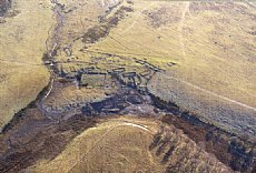 10/04/2021 - Easter Raitts township
Easter Raitts township Photo: Highland HER Although the Highlands is dotted with de... More >>
Find of the Month
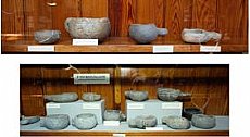 25/07/2022 - Steatite Vessels
These stone vessels, many with handles, were found at a variety of sites in Sutherland and... More >>